Hexographer 2’s Map Levels

We’re continuing to preview new/improved features in Hexographer 2. (No definitive ETA yet, but coming soon.) You can get more information and sign up for the official announcement email at this link.
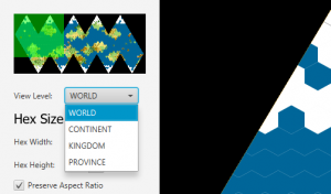
Next to undo/redo, I think the most requested feature for Hexographer 2 is the idea of being able to drill down on a map to greater levels of detail, and back up–all within the same file. We’re still refining this feature (so this may change) but the idea is that any world map file can have 4 levels: World, Continent, Kingdom and Province. Each map level is a map of the entire world, but zoomed out in such a way that the view is good for looking at the map at that level. And when you first switch between levels, you’ll be able to specify the difference. For example, you could make the the continent map 6 hexes across for every hex in the world map. Or make 9 hexes across in the kingdom map for every hex in the continent map. Etc.
When switching the map levels for the first time it will populate the next map up or down that hasn’t been created yet based on the hexes and shapes and lines on the map above or below. Changes on one level may effect the other levels depending on the object changed and what map level setting it may have.

Sounds fascinating. Is this feature going to take a lot more memory or processor power or time to render between levels?
Also, what can you tell us about text. Right now, placing and editing text is pretty click intensive. Are you going to make that easier?
This sounds awesome, especially that each lower level of the map will still be a full world map. A few questions come to mind:
1) What is the maximum number of hexes at any particular level? Using Hexographer now, it looks like we can have maps 500 hexes horizonally. Will that be a max for the world level? If we set 5 continent hexes per world hex, does that mean we can have a continent map 2500 hexes across?
2) Will lines we draw on one level copy over to another level? I’d love to show large rivers on the world level (like the Mississippi, Nile, or Amazon), and then gradually add smaller rivers & streams at lower levels so that they don’t clutter the high level map.
At the moment there are no bounds to the number of hexes. We are being very smart about only drawing the part of the map on screen, and so far it seems like a large number of empty hex objects (as long as they aren’t all being displayed) don’t take up too much space. But it is something I have to watch as development continues.