Worldographer/Hexographer 2 Programming Updates: River Generator Sample, Better Child Maps, & More
Things have been progressing on our update to Hexographer (the easy world map creator; aka Worldographer)! It is Kickstarting through Sept 14th. I’m really excited to show you a quick picture of the results of the river wizard/generator:
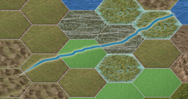
This was possible after adding elevation data to each hex. Each terrain type has a default elevation, then there is an algorithm that adjusts each hex’s elevation depending on the elevations of adjacent terrain. Anyway, I did add the drop shadow and move the two points for the mouth of the river to be flush with the hex edge, but this is basically the raw output. I’ll be iterating on it a bit further.
And while I was doing the elevation data, I thought I’d add resource data for each hex so that each hex has a value for lumber, crops, metals, and a few other resources. Which will allow us to open up another stretch goal to automatically place cities, villages, forts, mining camps, etc. based on these values (as well as adjacency to coasts/rivers and possible trade routes).
And that could lead to making a mini-Civilization style game to help you build your world. Have the program advance villages into towns then cities over time as you record some major happenings, if you want or do all that yourself. Maybe it devises some wars, plagues, locations of new villages/forts/etc., and so on or maybe you/the player does, or both. You’d be able to make notes about these things along the way. Maybe each person in your campaign is in charge of a culture and you collaboratively world-build. (If you’ve seen/played Dawn of Worlds, you’ve got a good idea of where this can go…)
OK, back to reality. I’ve also updated the child map functionality to be less uniform in the child map’s terrain. Partly that’s by randomly picking from similar terrain types to fill the parent hex’s area (Ex: light forest A, B, and C instead of all A) and partly looking at adjacent terrain and sprinkling a few of those in. Still need to sprinkle in a few related terrain. For example if the parent hex is forested hills, the child hex may have a couple plain forests as well as plain hills.
There’s a lot of other stuff I’ve been working on. I did have to work up very basic versions of the load/save/export options to make the sample maps I recently posted. I’ve also been working on the functionality behind the current stretch goal (Ruins Generator – it gives you the age of the ruins, what it was before, the state/type of decay and several other bullets.)
Of course, there have also been some bug fixes.