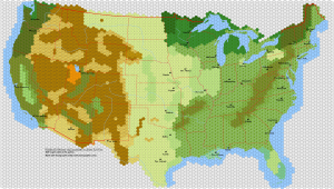
Giant Hex Map of the United States, circa late 1800s

To test the latest beta of Hexographer I thought it would be a good exercise to base in on a real map. I planned (and still do plan) to add in railroads using Hexographer’s new railroad icons, but that will have to wait. But because I wanted to experiment with the railroad icons, I thought I would dig up a US map from the late 1800s to use as an example.
The map shown here (click for the larger version) represents about four hours of work. But before you think that working with Hexographer (click the link and look for the “beta version” link near the top of the page) is time consuming, note that much of that time was spent getting the coastlines somewhat close to the real boundaries and researching which terrain should be placed in each area, marking the rivers, etc. If this was a fantasy world, it could be done much more quickly.
(But even though I spent a few hours on it, I’m sure there are places where the terrain isn’t quite right. Maybe some of the east coast forest should be heavy forest and maybe in other places it should be farmland. Feel free to make suggestions in the comments!)
Look for an updated version in the next few days with more symbols, railroads, and terrain corrections.

I love this map, though I should mention that Seattle is actually on the Puget Sound, approximately two hexes north of where you have it. Portland isn’t an inland city either. It’s nearer to the mouth of the Columbia River.
Thanks for pointing those out. I’ll more carefully check the locations when I post an updated map.
Nice. Any chance of getting the .hxm file on this and your other maps?
I’m hoping to update the “Samples” page in the near future…